Анлайн версія аўдыягіда "Лідскі замак"
Эбстарфская карта свету (копія)
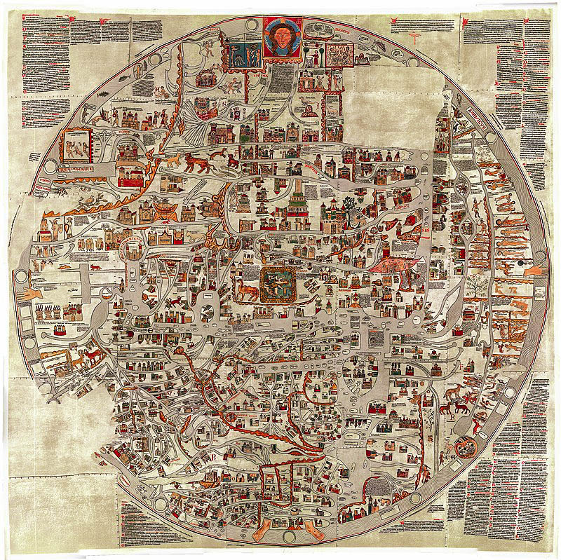
Эбстарфская карта – самая вялікая па памерах сярэднявечная карта свету VIII – XIII стагоддзяў з тых, якія захаваліся да XX стагоддзя.
Арыгінал карты быў страчаны падчас бамбардзіроўкі Гановера ў 1943 годзе. Яна змяшчала больш за 1600 надпісаў, якія абазначалі не толькі геаграфічныя аб'екты, але і асаблівасці прыроды, а таксама падзеі біблейскай гісторыі і антычнай міфалогіі.
Стварэнне карты звязваецца з імем Гервасія Тыльберыйскага, кіраўніка Эбстарфскага манастыра (на поўдні ад Гамбурга), у якім яна была знойдзена ў XIX стагоддзі.
На карце сустракаецца ці не першая картаграфічная выява такіх тапонімаў як Полацк (Plosceke), Смаленск (Smalentike), Нёман (Memela), Лівонія (Livonie), Рыга (Riga). Полацк і Смаленск апынуліся на адной рацэ – Дзвіне, і Смаленск аказаўся бліжэй да мора, чым у рэальнасці. На адной рацэ таксама аказаліся Ноўгарад і Кіеў.
Карта ўяўляла сабой эсхаталагічную карціну свету, свайго роду ікону, на пазачасавым полі якой дэманстраваліся Пачатак і Канец Свету. Зямля прадстаўлена ў выглядзе Цела Хрыстова (галава на Усходзе, рукі ў малітоўным жэсце павернуты далонямі да гледача – на Поўначы і на Поўдні, ногі Хрыста – на Захадзе) у суправаджэнні цытаты 16 верша 117 псалма.